Handy Maps
London on a Glove
 |
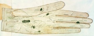
George Shove, map of London created on a glove for the Great Exhibition (1851). National Archives of the United Kingdom.
|
To guide tourists to and through the exposition grounds, mapmakers issued specialized items, which often rivaled the inventiveness and visual allure of the displays themselves. For the first modern world’s fair, the Great Exhibition held in London in 1851, George Shove configured a map of London on a lady’s glove. The glove highlighted the location of the exposition with a sketch of its distinctive building, the iron-and-glass Crystal Palace designed by James Paxton, near the base of the palm. Recognizing that most out-of-town visitors would want to tour the city as well as the exhibition, Shove illustrated the relative positions of other prominent destinations, picturing St. Paul’s Cathedral across two fingers, the Colosseum on the thumb, and Kensington Gardens near the wrist. This wider territory meant that the glove could continue to serve tourists after the exhibition closed. If the glove advertised London’s major attractions, they in turn enhanced the glove’s desirability as a fashionable accessory.
Follow the Horn
|
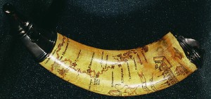
Powder horn incised with map of Hudson and Mohawk river valleys (ca. 1757). Library of Congress.
|
In the eighteenth century, specialized vernacular traditions of mapmaking proliferated. During the Seven Years’ War and the Revolutionary War in North America, soldiers used their jackknives to engrave maps and other decorations on their powder horns. Such scratched designs are the oldest form of graphic art, and the soldiers’ handiwork was a counterpart to sailors’ scrimshaw artistry. Professional engravers, gunsmiths, and comb makers occasionally decorated horns, but most often the individual owners executed the work.
Eighteenth-century soldiers carved maps for practical reasons. Much of the territory contested in the Seven Years’ War was uncharted, and printed maps of the area were rare. It thus seems likely that powder horns recorded some geographic information for the first time. This horn features the two most frequently represented paths from New York to Canada, one through the Hudson River and Lake Champlain and the other by way of the Hudson and Mohawk rivers and Lake Ontario. Both were strategic routes during the conflict and essential to the trade with Native Americans. The horn enumerates many of the forts and towns along these paths, while also representing New York City, the British royal coat of arms, and an assortment of boats, houses, and windmills.
Fan of the Empire
|
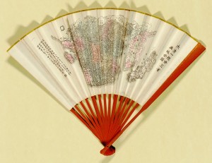
Shenjang mo xiang gu, "Da Qing yi tong nian san sheng yu di quan tu" (Complete Geographic Map of the Governance of the Twenty-Three Provinces of the Great Qing) (1890). Library of Congress.
|
Images of maps on clothing and fashion accessories convey similar meanings in a more intimate, body-centered way. Some of the earliest examples, dating back to sixteenth-century Japan, were maps painted on fans. An important part of the ceremonial dress of aristocrats and courtiers, collapsible fans typically featured brightly painted decorations; most were pictorial, but a few featured maps. By the nineteenth century, printed maps appeared on fans in Japan and China. Souvenir manufacturers in the United States expanded on the trend, producing maps on fans as world’s fair mementos. Clothes decorated with historical maps preserve a sense of the Asian fans’ dignity. Visitors to Hawaii can buy shirts featuring maps of Captain James Cook’s eighteenth-century voyage to the islands, while more formal dressers might favor silk ties or scarves printed with antique maps. Most wearable maps, however, are more frivolous, such as the tube socks decorated with maps of the London Underground.