A Journey Through Latin American Maps
| ||
SOME INTERNET RESOURCES |
||||||
| History of Cartography | Bibliographies & Links | Online Exhibitions | Digital Map Collections | Journals | Geography Institutes | Maps from Mapping Latin America Available Online |
|
HISTORY OF CARTOGRAPHYSee the website for the History of Cartography Project for updates and indices of the most comprehensive secondary source on the subject. For online resources see the gateway page, History of Cartography website. For an overview on mapping topics such as projection, coordinate systems, etc., see Peter H. Dana’s webpage. See also Latitude: Science of Sailing (P. Seed, Rice University). Online resources and map collections, the most extensive collections include David Rumsey and US Library of Congress: Map Collections, 1550-present; part of the American Memory series of collections available online, as well as the John Carter Brown Library’s Archive of Early American Images, Yale University’s Digital Images Online (from their rare book & manuscript collection), manuscript and printed maps in Spain’s Biblioteca Digital Hispanica, and the Bibliothèque Nationale (France)’s online resources at Gallica. For vocabularies & definitions, a good starting point is the Glossary of Cartographic Terms at the Perry-Castañeda Library (University of Texas).
BIBLIOGRAPHIES & LINKS
EXHIBITS RELATING TO CARTOGRAPHY & LATIN AMERICA
CARTOGRAPHY COLLECTIONS & WEBSITESWorld Digital Library has a growing number of images, including maps, of and from Latin America. Old Maps Online has a growing collection of old maps georeferenced (mapped onto) contemporary maps. Biblioteca Digital del Patrimonio Iberoamericano is a similar collection, focusing on Iberoamerica. Although the Internet Archive does not have a sophisticated search interface, it does have a growing number of materials for the persistent researcher. europe
latin america
north america
ethnocartography & GIS
JOURNALS
SOME MAPS FROM THE VOLUME AVAILABLE ONLINEWaldseemuller World Map (Universalis Cosmographia) (1507); (Entire map); see also website on MartinWaldseemuller Tenochtitlán 1524 (Yale, Beinecke)
Relaciones Geográficas, Cholula & Text of the Questionnaire (Benson Library) Oztoticpac Land Map and discussion (Library of Congress); Map only
Pedro Cieza de León, Perú (Yale, Beinecke) from Cieza de Leon, Pedro de, 1518-1554. La prima parte dell historie del Perv. Dove si tratta lordine delle prouincie, delle citta nuoue in quel paese edificate, i riti, & costumi de gli Indiani, con molte cose notabili, et degne di consideratione...In Venetia, Appresso Giordano Ziletti, al segno della Stella. MDLX. Guaman Poma de Ayala Website, Mapa Mundi & Land Dispute Map (Royal Library, Denmark) Herman Moll, A Map of the West Indies..., 1715
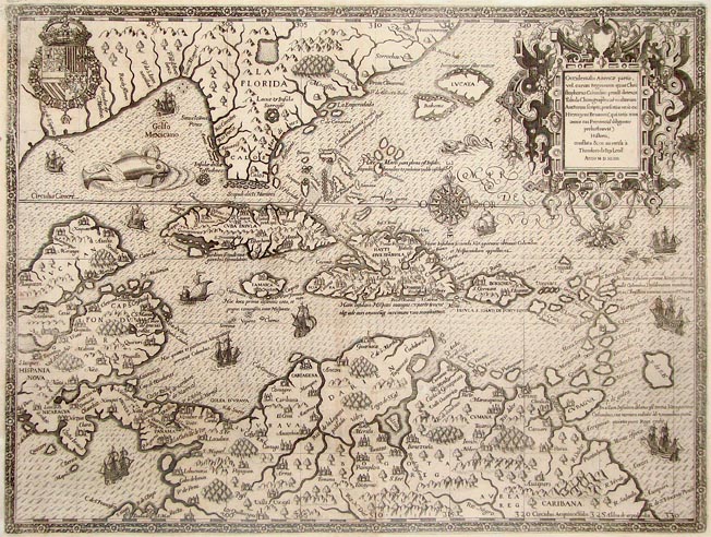
Alexander von Humboldt, Geographie des plantes equinoxiales. / Tableau physique des Andes et Pays voisins... (Yale, Beinecke), from Humboldt, Alexander von, 1769-1859. Essai sur la geographie des plantes, accompagne dun tableau physique des regions equinoxiales, fonde sur des mesures executees, depuis le dixieme degre de latitude boreale jusquau dixieme degre de latitude australe, pendant les annees 1799, 1800, 1801, 1802 et 1803, Paris : F. Schoell, 1807. See also the Humboldt Digital Library, interactive map of Chimborazo. Lionel Lisborne, Topographical map a portion of the Isthmus of Darien... (1854) Agustin Codazzi, Provincia de Velez (1855) Antonio García Cubas, Carta General de la República Mexicana (1858) (David Rumsey Collection). The entire atlas is available for consultation. Text of Lucio Costa Report of the Pilot Plan for Brasilia and some drafts. For information on Costa, see also the webpage of the Casa Lucio Costa (Brazil) Video: Bjorn Sletto, Inna Kowantok, and article Mapping the Gran Sabana (Americas 2005) some related maps & resourcesUniversalis Cosmographia (1545) from Honter, Johannes, 1498-1549. Rudimenta cosmographica Impressvm in inclyta Transylvaniae Corona 1542. An Hydrographical Draught of Mexico as it Lies in its Lakes (1725). From Herrera y Tordesillas, Antonio de, d. 1625. The general history of the vast continent and islands of America ... London, Printed for J. Batley, 1725-26. Richard Ligon, Map of Barbados (17c) (Yale, Beinecke) from Ligon, Richard, A true and exact history... London 1657 Universitty of Arizona Webpage on Antonio de Herrera and the Historia General Antonio Herrera, Descripción
de la audience de Panamá (Yale, Beinecke); Descripción
de l’audience del Nuevo Reino From Herrera y Tordesillas, Antonio
de, d. 1625. Paraguay, O Prov. de Rio de la Plata cum adiacentibus Provinviis quas vocant Tucuman, et Sta. Cruz de la Sierra (1640) (Yale, Beinecke) in Laet, Joannes de, 1593-1649. Lhistoire dv Nouveau monde on Description des Indes Occidentales, contenant dix-huit liures...enrichi de nouuelles tables geographiques & figures des animaux, plantes & fruicts A Leyde : Chez B. & A. Elseuiers, 1640. Texts of Jesuit Relations (Canadian Archives) Robert Schomburgk Letter of 23 December 1844 to British Parliament on the preparation and submission of his map of Guyana, and Full list of his reports Plano topográfico de la ciudad de Santiago de Chile (1856) and (1871); Sala Virtual de Cartografía Chilena, Cartografía Urbana (mostly 18-early 20 c.) Comisión de Límites, Linea Divisoria entre México y Estados Unidos, 1901 (book of 19 maps) Mapa de los ferrocariles en explotación, República de Argentina, Ministerio de Obras Públicas, Dirección general de ferrocarriles, Año de 1924 Outline of the automobile roads in Mexico drawn specially for Terry’s Guide to Mexico. (Mexico) in Terry, T. Philip (Thomas Philip), 1864-1945. Terry’s guide to Mexico : the new standard guidebook to the Mexican Republic : with chapters on the railways, airways, automobile roads and the ocean routes to Mexico Boston ; New York : Houghton Mifflin Company, 1935. Bjorn Sletto, Inna Kowantok, video on mapping the Pemon homeland (Venezuela)
NATIONAL GEOGRAPHY INSTITUTES OF LATIN AMERICA
|
||
©2011, 2013 Jordana Dym & Karl Offen • Please contact Jordana Dym
or Karl Offen
with comments or suggestions. |
||